AI-Based Water Quality Prediction for Inland Water using Satellite and Land Surface Model Data

February 17, 2025

Significance of Water Quality Prediction and AI 

Heatwaves and disruptions in water cycle systems driven by climate change are increasingly impacting the water quality (WQ) of inland waters. Ensuring the maintenance of WQ is critical for both environmental sustainability and effective water resource management. Traditional methods, such as monitoring WQ indicators (e.g., chlorophyll-a, dissolved oxygen, total phosphorus, total nitrogen, water temperature) through WQ observatories are often labor-intensive and limited in spatial and temporal coverage.

Our Goal 

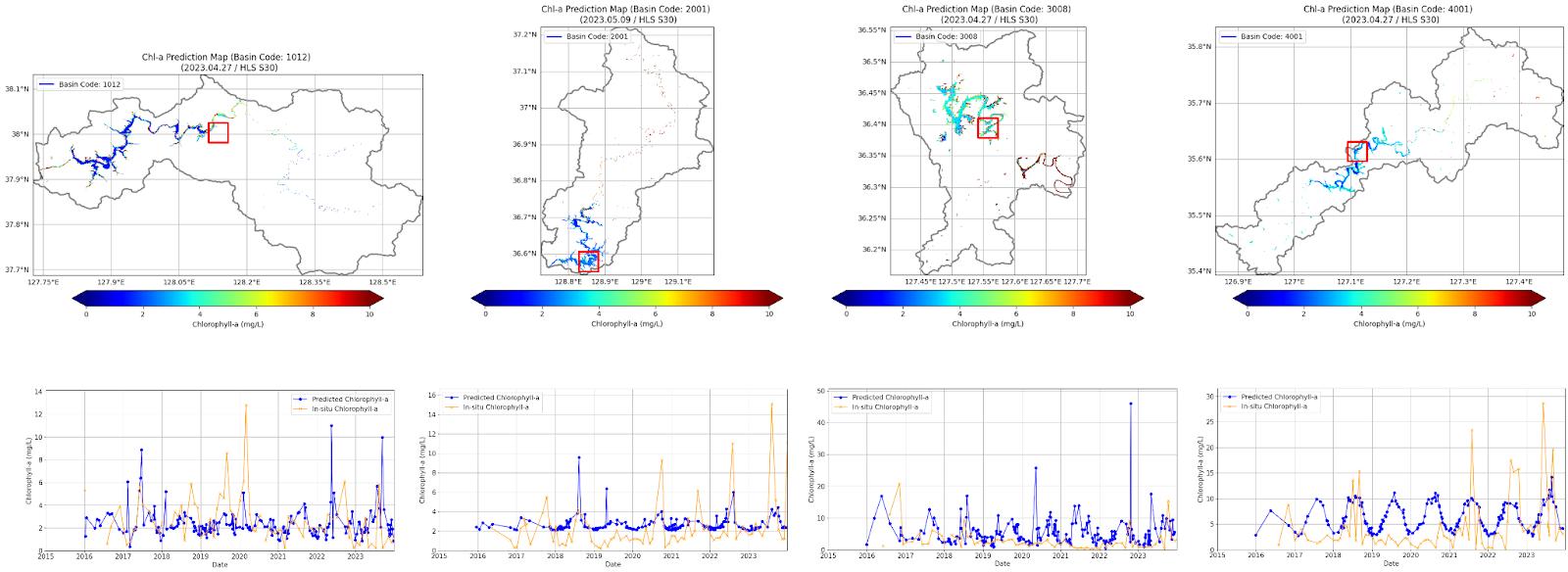
We aim to develop a robust AI-based prediction model to estimate chlorophyll-a concentrations in inland lakes and rivers. By enhancing prediction accuracy and expanding spatial coverage, this project aims to strengthen efforts to monitor and address water pollution, eutrophication, and other critical environmental issues.

Our Approach 

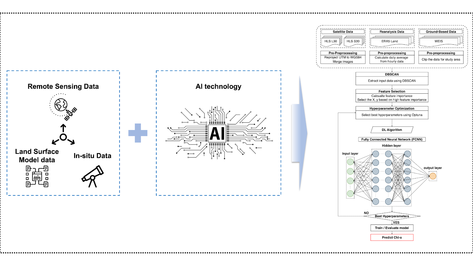
Our approach integrates high-resolution satellite images (e.g., Landsat-8/9 and Sentinel-2/3, etc) with key environmental variables from land surface models (e.g, ERA5 Land, GLDAS and MERRA-2, etc). The model accounts for the distinct characteristics of lakes and rivers, enabling customized solutions for each water body type. 

Future research plans include incorporating socio-statistical data, such as population density and livestock metrics, as well as climate change scenarios (e.g., RCP and SSP). This will allow us to develop predictive models that account for the influence of human activities and long-term climate dynamics. 

By expanding the range of data inputs and leveraging AI's predictive capabilities, we aim to provide a comprehensive solution for understanding and mitigating the impacts of climate change on the WQ of inland waters.

Tools and Expertise 

Our research combines a variety of data sources, technologies, and domain expertise: 

Programming: Python for data processing, model training, and visualization. 

Spatial Analysis: GIS tools for mapping and spatial data interpretation. 

Computing: High-performance computing to process and analyze large datasets. 

Domain Knowledge: Expertise in hydrology and environmental science for interpreting results. 

Key Areas of Research Interest 

In addition to chlorophyll-a prediction, our project explores the following topics: 

  • Investigating AI approaches for low-concentration chlorophyll-a prediction in rivers. 
  • Analyzing the impact of environmental factors (e.g., precipitation, flow speed) on WQ. 
  • Developing transfer learning methods for regional and global inland water prediction. 
  • Exploring multi-sensor data fusion to enhance model accuracy and scalability. 
  • Incorporating uncertainty quantification into prediction models for decision-making. 
  • Extending the methodology to other WQ indicators like turbidity and dissolved oxygen.

Contact

Read other projects

Multi-Scale Soil Moisture Monitoring Using ELBARA-III and Drone Radiometer

The Portable L-Band Radiometer, mounted on a drone, enables high-resolution soil moisture retrieval across diverse terrains. Operating at 1.4 GHz (L-band), it collects brightness temperature (TB) data over rice paddies and varied vegetation zones, complementing satellite missions like SMAP and SMOS. By integrating airborne observations with ground-based sensors, the system enhances spatial coverage and improves soil moisture retrieval models for climate and agricultural applications. This drone-based approach significantly increases data accuracy and efficiency compared to traditional methods.

Read this project
Developing the First Long-Term Soil Moisture and Brightness Temperature Measurement Site in South Korea Using L-Band Radiometers and Drones

Soil moisture (SM) is vital for hydrometeorology and agriculture, yet its retrieval faces challenges. Satellite-based methods (e.g., SMAP, SMOS) offer global coverage but have resolution limitations, model-based methods lack accuracy in extreme events, and ground-based observations provide precision but limited coverage. To improve satellite SM validation, this project establishes Korea’s first Core Validation Site (CVS) in Hampyeong-gun and Naju-si, deploying TEROS 12-6 sensors across 9 km, 3 km, and 1 km grids for continuous SM and temperature monitoring. The ESA ELBARA-III L-Band Radiometer and drone-mounted PoLRa will collect brightness temperature (TB) data, aiding SM retrieval model development with soil properties and climate data. This CVS will enhance climate resilience studies, SM monitoring, and satellite validation in Korea.

Read this project
AI-Based Water Quality Prediction for Inland Water using Satellite and Land Surface Model Data

Climate change-driven heatwaves and water cycle disruptions threaten inland water quality (WQ), necessitating efficient monitoring. Traditional methods are labor-intensive with limited coverage, prompting us to develop an AI-based model for predicting chlorophyll-a concentrations in lakes and rivers. By integrating high-resolution satellite imagery (Landsat-8/9, Sentinel-2/3) with land surface models (ERA5-Land, GLDAS, MERRA-2), our model tailors predictions to different water bodies. Future plans include incorporating socio-statistical data (e.g., population, livestock) and climate scenarios (RCP, SSP). Using AI, GIS, and high-performance computing, we explore low-concentration chlorophyll-a prediction, precipitation and flow speed impacts on WQ, transfer learning, multi-sensor data fusion, and uncertainty quantification. Beyond chlorophyll-a, we aim to extend predictions to turbidity and dissolved oxygen, providing a comprehensive AI-driven approach to monitoring and mitigating climate change effects on inland water quality.

Read this project
Harnessing Deep Learning to Predict and Decode the Mysteries of Flash Droughts (GAN/SHAP/3D-CNN with Transfer Learning)

The application of deep learning in predicting flash droughts offers a transformative approach to understanding and anticipating these rapid-onset events, significantly enhancing preparedness and response strategies. By unraveling the complex mechanisms behind flash droughts, this project aims to provide precise, timely forecasts, thereby mitigating the severe agricultural, ecological, and socioeconomic impacts associated with these phenomena.

Read this project
Streamflow and Drought Predictions over Ungaged Regions using Deep and Transfer Learning Approaches

Streamflow and flash drought predictions are essential for managing water resources and mitigating potential disasters in ungaged regions. With remotely-sensed data, deep and transfer learning approaches provide powerful tools to analyze complex hydrological data, enabling more accurate predictions and better decision-making in these areas.

Read this project
Applications of Bayesian Machine Learning in Big Data in Earth Science

Bayesian methods help us improve our guesses by using new information. In Earth science, these methods are applied to big data to better understand our planet. This approach is useful for predicting things like natural disaster patterns and climate changes. By continuously updating our knowledge with new data, we can make more accurate predictions and decisions in Earth science.

Read this project
Water Balance Budgeting with Bayesian Machine Learning

The water balance equation in Earth science, P = E + R + etc, describes the relationship between precipitation (P), evaporation (E), runoff (R), and etc (e.g., soil moisture, ground water) in a given area. Bayesian inference can be applied to solve this equation by incorporating prior knowledge and updating the probability distributions of the variables based on new data, ultimately improving water resource management and prediction.

Read this project
Integrating Earth Science and Engineering for Climate Resilience: Innovative Approaches to Infrastructure and Societal Justice

Earth science informs infrastructure development by providing insights into site suitability, resource management, and sustainable design, enhancing the resilience and long-term viability of projects. It also plays a crucial role in addressing societal justice related to climate change by helping identify vulnerable communities and develop mitigation strategies, ensuring equitable access to resources and protection from environmental hazards.

Read this project
Enhancing Earth Science Predictions through Advanced Data Assimilation Techniques

Data assimilation is vital in earth science as it integrates diverse observations and model simulations, improving the accuracy of forecasts and predictions. This process enhances our understanding of complex Earth systems, enabling better decision-making for environmental management and climate adaptation.

Read this project
Floods and Droughts Predictions using Machine Learning Approaches

Satellite data and machine learning transformed Earth science by predicting and monitoring natural disasters. This combination delivers precise and timely predictions, crucial for mitigating the impacts of events like floods and droughts.

Read this project
Data Error Characterizations

Characterizing the error of satellite data and land surface models is vital in Earth science, as it ensures the accuracy and reliability of information used for monitoring and predicting environmental phenomena. By understanding these errors, scientists can refine data interpretation, enhance models, and ultimately make better-informed decisions about the Earth's complex systems.

Read this project
Developing Algorithms to Improve the Temporal Sampling of Satellite Data

Enhancing the temporal repeat of satellite data for obtaining soil moisture information is a vital research area due to its implications for agriculture, water resource management, climate change research, and ecosystem health. It helps in making informed decisions, increasing productivity, and reducing the impact of natural disasters, as well as contributing to our understanding of the global climate system.

Read this project
Exploring the Impact of Human Activities on the Subdaily Global Terrestrial Water Cycle

Humans have been modifying the Earth's surface for thousands of years, with practices like clearing forests for agriculture and creating uniform land covers. But how do these changes impact the subdaily global terrestrial water cycle? That's the question a project aims to answer.

Read this project
Satellite Image Disaggregation with Machine Learning

Microwave soil moisture data is critical for agriculture, weather, and climate modeling, but has low spatial resolution. Disaggregation via machine learning can improve resolution, offering detailed local soil moisture data. Machine learning can handle complex relationships between microwave signals and soil moisture.

Read this project