Developing the First Long-Term Soil Moisture and Brightness Temperature Measurement Site in South Korea Using L-Band Radiometers and Drones

February 17, 2025

Importance of Soil Moisture and Retrieval Processes

Soil moisture (SM) is an important variable in hydrometeorological models. It affects numerous phenomena and gets affected at the same time, like precipitation, runoff, vegetation growth, infiltration to groundwater, and evapotranspiration. Also, soil moisture is highly related to agriculture, one of the most important industries in human society.

There have been various methods to understand soil moisture of a specific place at a specific time, and there are three methods in big criteria. Satellite-based methods are the most prevailing method recently, and also a really powerful method. It can cover a large area at one time, varying by orbit type but it can cover the entire Earth as well. However, satellite-based retrieval has a limitation of resolution, for both temporal and spatial resolution. Because satellites orbit the Earth, it is impossible to get continuous data for a specific area. It is true that stationary orbit can compensate for this drawback, then there is no reason to use a satellite instead of direct investigation. For major soil moisture missions, like Soil Moisture Active Passive (SMAP) from NASA and Soil Moisture and Ocean Salinity (SMOS) have 2 to 3 days of revisiting time, and sometimes it may be longer due to unexpected occasions making data unavailable.

Also, compared to other methods, spatial resolution is still not as good as the others. Because the satellite orbits the Earth, it has a long distance from the investigating place and the sensor attached in the satellite. First, the distance is long, and second, there is an atmosphere between them. Because of these two factors, there is always an issue for uncertainty in satellite-based datasets. Because the signal is traveling long distances, there is a limit of each mission’s spatial resolution. The resolution varies by missions, for instance SMAP and SMOS missions use a 25 km EASEgrid system. But still, there have been attempts to overcome this limitation, some datasets offer better resolution, for instance SMAP L3 Enhanced dataset offers a 9 km EASEgrid system.

Second method is model analysis. There have been a lot of hydrometeorological models depicting the Earth, and lots of them are having good performance. However, the biggest problem for the model is that it cannot be used only, since the model data cannot predict completely accurately for the unexpected events, especially when having more and more extreme events due to climate change. Thus, inconsistent accuracy of the model is a big limitation.

Final method is ground observation, which is directly investigating the place. It is pretty evident that this method has a coverage issue. Of course the Earth is so large, and because of lots of realistic reasons, it is impossible to cover all of them with sensors and retrieve soil moisture. Not only the soil moisture retrieval, all the ground observation has the same problem. Nonetheless, it has the best accuracy as well as consistent and continuous data, so it is a powerful method if investigating on a small area.

Core Validation Site (CVS)

Because of uncertainty in satellite-based dataset, lots of sites have been built for validating the retrieved dataset from satellites. By comparing the data from satellite and ground observation, it is possible to calibrate the system. Unfortunately, no CVS site has been built in Korea, so advanced level of soil moisture retrieval in Korea is restricted a lot. There are lots of sites with sensors, but not sophisticated as NASA’s CVS guideline has mentioned.

According to NASA’s requirements for automated soil measurements, there should be 12 sensors in a 33 km grid cell, 8 sensors in a 9 km grid cell, 6 sensors in a 3 km grid cell and 1 km grid cell. Currently, 9 km, 3 km, and 1 km grid cell candidate sites are settled, so the soil moisture sensor will be deployed there to retrieve soil moisture directly.

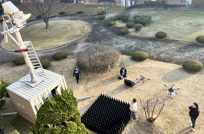
Below figure, Fig. a shows the total research area in this project. The CVS is mainly located in Hakgyo-myeon, Hampyeong-gun, Jeollanam-do. Some part of the research area includes Hampyeong-eup, Daedong-myeon, Eomda-myeon in Hampyeong-gun and Munpyeong-myeon, Dasi-myeon, Gongsan-myeon, Donggang-myeon in Naju-si.

Fig. b shows the 9 km grid cell, and the candidate sites are depicted as red. Fig. d shows the 3 km grid cell, and the candidate sites are depicted as green. Also, the green cell in Fig. b is the same cell in Fig. d. Finally, Fig. c shows the 1 km grid cell, and the candidate sites are depicted as white. Samely, the white cell in Fig. d is the same cell in Fig. c.

When the CVS is fully prepared, all these locations will have sensors to retrieve soil moisture in different places. The location for each sensor is selected when having homogeneous vegetation, so that errors and uncertainties occurring from different types of vegetation and soil can be minimized. Also the selection of the sites are advised by NASA researchers, who actually run the CVS sites in other countries. For further information, look up (Link) for NASA researchers visiting GIST.

Radiometer and other Instruments

In the CVS site, there will be one radiometer center, and one drone-based radiometer, and several sensors in different places. Designed by the European Space Agency (ESA), ESA L-Band Radiometer (ELBARA-III) will be the main radiometer here. L-Band (around 1.41 GHz microwave signal) is used in a lot of soil moisture satellite missions. Not only ELBARA-III, there will be two more radiometers, which is the Portable L-Band Radiometer (PoLRa). One of them will be attached in ELBARA-III tower, and the other will be attached to a drone, enabling it to retrieve airborne data. For further information about radiometers, look up for (link).

In each grid cell, TEROS 12-6 soil moisture sensors will be deployed, retrieving soil moisture, soil temperature, electrical conductivity, pressure and logger temperature. Among them, soil moisture and soil temperature will be important values for CVS dataset, working as a validation data there. Also, the sensor is connected to a controller which runs in a solar panel, expecting to run without disturbed by manpower.

Goal of the project

Basic goal of the project is to build a CVS site, which will be the first CVS site in Korea. With all the instruments prepared, it is expected to retrieve brightness temperature(TB) from radiometer, and soil moisture directly from the TEROS sensor. Next, a model converting from TB value to soil moisture will be built, and lots of ancillary data, such as soil temperature, soil information(clay fraction / sand fraction / silt fraction), soil roughness, soil porosity and emissivity will also be input data of the model. With this model, it is expected to retrieve soil moisture value from the radiometer.

Contact

Read other projects

Multi-Scale Soil Moisture Monitoring Using ELBARA-III and Drone Radiometer

The Portable L-Band Radiometer, mounted on a drone, enables high-resolution soil moisture retrieval across diverse terrains. Operating at 1.4 GHz (L-band), it collects brightness temperature (TB) data over rice paddies and varied vegetation zones, complementing satellite missions like SMAP and SMOS. By integrating airborne observations with ground-based sensors, the system enhances spatial coverage and improves soil moisture retrieval models for climate and agricultural applications. This drone-based approach significantly increases data accuracy and efficiency compared to traditional methods.

Read this project
Developing the First Long-Term Soil Moisture and Brightness Temperature Measurement Site in South Korea Using L-Band Radiometers and Drones

Soil moisture (SM) is vital for hydrometeorology and agriculture, yet its retrieval faces challenges. Satellite-based methods (e.g., SMAP, SMOS) offer global coverage but have resolution limitations, model-based methods lack accuracy in extreme events, and ground-based observations provide precision but limited coverage. To improve satellite SM validation, this project establishes Korea’s first Core Validation Site (CVS) in Hampyeong-gun and Naju-si, deploying TEROS 12-6 sensors across 9 km, 3 km, and 1 km grids for continuous SM and temperature monitoring. The ESA ELBARA-III L-Band Radiometer and drone-mounted PoLRa will collect brightness temperature (TB) data, aiding SM retrieval model development with soil properties and climate data. This CVS will enhance climate resilience studies, SM monitoring, and satellite validation in Korea.

Read this project
AI-Based Water Quality Prediction for Inland Water using Satellite and Land Surface Model Data

Climate change-driven heatwaves and water cycle disruptions threaten inland water quality (WQ), necessitating efficient monitoring. Traditional methods are labor-intensive with limited coverage, prompting us to develop an AI-based model for predicting chlorophyll-a concentrations in lakes and rivers. By integrating high-resolution satellite imagery (Landsat-8/9, Sentinel-2/3) with land surface models (ERA5-Land, GLDAS, MERRA-2), our model tailors predictions to different water bodies. Future plans include incorporating socio-statistical data (e.g., population, livestock) and climate scenarios (RCP, SSP). Using AI, GIS, and high-performance computing, we explore low-concentration chlorophyll-a prediction, precipitation and flow speed impacts on WQ, transfer learning, multi-sensor data fusion, and uncertainty quantification. Beyond chlorophyll-a, we aim to extend predictions to turbidity and dissolved oxygen, providing a comprehensive AI-driven approach to monitoring and mitigating climate change effects on inland water quality.

Read this project
Harnessing Deep Learning to Predict and Decode the Mysteries of Flash Droughts (GAN/SHAP/3D-CNN with Transfer Learning)

The application of deep learning in predicting flash droughts offers a transformative approach to understanding and anticipating these rapid-onset events, significantly enhancing preparedness and response strategies. By unraveling the complex mechanisms behind flash droughts, this project aims to provide precise, timely forecasts, thereby mitigating the severe agricultural, ecological, and socioeconomic impacts associated with these phenomena.

Read this project
Streamflow and Drought Predictions over Ungaged Regions using Deep and Transfer Learning Approaches

Streamflow and flash drought predictions are essential for managing water resources and mitigating potential disasters in ungaged regions. With remotely-sensed data, deep and transfer learning approaches provide powerful tools to analyze complex hydrological data, enabling more accurate predictions and better decision-making in these areas.

Read this project
Applications of Bayesian Machine Learning in Big Data in Earth Science

Bayesian methods help us improve our guesses by using new information. In Earth science, these methods are applied to big data to better understand our planet. This approach is useful for predicting things like natural disaster patterns and climate changes. By continuously updating our knowledge with new data, we can make more accurate predictions and decisions in Earth science.

Read this project
Water Balance Budgeting with Bayesian Machine Learning

The water balance equation in Earth science, P = E + R + etc, describes the relationship between precipitation (P), evaporation (E), runoff (R), and etc (e.g., soil moisture, ground water) in a given area. Bayesian inference can be applied to solve this equation by incorporating prior knowledge and updating the probability distributions of the variables based on new data, ultimately improving water resource management and prediction.

Read this project
Integrating Earth Science and Engineering for Climate Resilience: Innovative Approaches to Infrastructure and Societal Justice

Earth science informs infrastructure development by providing insights into site suitability, resource management, and sustainable design, enhancing the resilience and long-term viability of projects. It also plays a crucial role in addressing societal justice related to climate change by helping identify vulnerable communities and develop mitigation strategies, ensuring equitable access to resources and protection from environmental hazards.

Read this project
Enhancing Earth Science Predictions through Advanced Data Assimilation Techniques

Data assimilation is vital in earth science as it integrates diverse observations and model simulations, improving the accuracy of forecasts and predictions. This process enhances our understanding of complex Earth systems, enabling better decision-making for environmental management and climate adaptation.

Read this project
Floods and Droughts Predictions using Machine Learning Approaches

Satellite data and machine learning transformed Earth science by predicting and monitoring natural disasters. This combination delivers precise and timely predictions, crucial for mitigating the impacts of events like floods and droughts.

Read this project
Data Error Characterizations

Characterizing the error of satellite data and land surface models is vital in Earth science, as it ensures the accuracy and reliability of information used for monitoring and predicting environmental phenomena. By understanding these errors, scientists can refine data interpretation, enhance models, and ultimately make better-informed decisions about the Earth's complex systems.

Read this project
Developing Algorithms to Improve the Temporal Sampling of Satellite Data

Enhancing the temporal repeat of satellite data for obtaining soil moisture information is a vital research area due to its implications for agriculture, water resource management, climate change research, and ecosystem health. It helps in making informed decisions, increasing productivity, and reducing the impact of natural disasters, as well as contributing to our understanding of the global climate system.

Read this project
Exploring the Impact of Human Activities on the Subdaily Global Terrestrial Water Cycle

Humans have been modifying the Earth's surface for thousands of years, with practices like clearing forests for agriculture and creating uniform land covers. But how do these changes impact the subdaily global terrestrial water cycle? That's the question a project aims to answer.

Read this project
Satellite Image Disaggregation with Machine Learning

Microwave soil moisture data is critical for agriculture, weather, and climate modeling, but has low spatial resolution. Disaggregation via machine learning can improve resolution, offering detailed local soil moisture data. Machine learning can handle complex relationships between microwave signals and soil moisture.

Read this project