Floods remain one of the most destructive natural disasters worldwide, yet their impacts are often hardest to assess in the places where information is needed most. In many regions, ground-based observations are sparse, inaccessible, or completely unavailable because of political, logistical, or physical barriers. These data-denied regions create a major blind spot for flood response, humanitarian aid, and long-term resilience planning.
Satellite remote sensing offers a powerful alternative because it can observe flooded landscapes rapidly and consistently over large areas. In particular, Synthetic Aperture Radar, or SAR, is highly valuable because it works in all weather conditions and during both day and night, which is essential during extreme flood events. However, accurately translating satellite signals into reliable flood maps remains challenging, especially when models trained in one region are deployed to a completely different environment.
This project addresses that challenge by investigating how AI and advanced satellite-derived PolSAR features can be used not only to detect flood extent, but also to assess flood impacts in inaccessible and data-denied regions with greater robustness and reliability.
Our Goal
The goal of this project is to develop a flood mapping framework that can operate reliably in regions where local observations, training data, and field validation are unavailable.
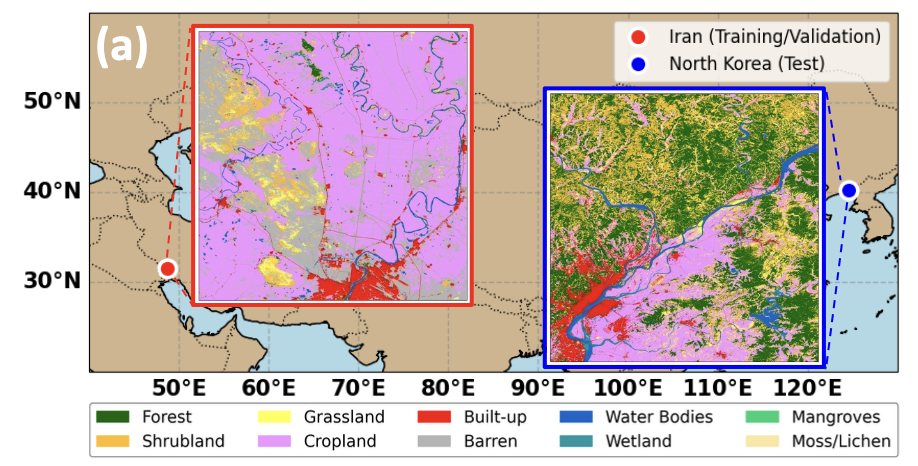
Rather than building a model that performs well only in one familiar location, we aim to create a domain-robust system that can generalize across sharply contrasting environments. In this project, models were trained in an arid flood-prone region in Iran and then directly applied, without retraining, to a monsoonal and data-denied region in North Korea. This setup simulates a real emergency situation where a pre-existing model must be deployed immediately in a new and unfamiliar disaster zone.
Our broader objective is not only to identify where floodwaters are present, but also to investigate what has been affected, including agricultural land, vegetation, and built-up urban areas. This makes the project directly relevant for disaster response, infrastructure risk assessment, and humanitarian planning.
Why AI and Satellite Data Matter for Flood Impact Investigation
Traditional flood mapping methods often depend on local calibration, in situ data, or event-specific training samples. In inaccessible regions, those resources are often unavailable. This makes it difficult to build rapid and trustworthy flood impact assessments using conventional methods alone.
Satellite data provide a scalable solution, but raw satellite intensity signals are highly sensitive to local environmental conditions such as soil moisture, vegetation, terrain, and land cover. As a result, a deep learning model trained in one region may fail badly in another if it relies too heavily on region-specific backscatter patterns.
This is where AI becomes essential. Advanced deep learning models can learn complex spatial patterns in flood imagery, while carefully selected PolSAR decomposition and texture features can help the model focus on structural flood signatures that remain more stable across regions. In other words, AI allows the system to move beyond simple pixel intensity and learn transferable patterns of inundation, boundary structure, and water-body geometry.
By combining satellite remote sensing with AI, the project seeks to overcome one of the biggest barriers in global flood monitoring: the lack of reliable flood information in places where ground access is limited or impossible.
Our Approach
The project uses Sentinel-1 dual-polarization SAR data as the primary source for flood detection. These data are processed to extract multiple categories of flood-relevant information, including intensity features, polarimetric decomposition features, and textural metrics.
From this large feature pool, metaheuristic optimization is used to identify the most informative and transferable subset of features. Interestingly, the best-performing feature subset was dominated by texture-based information rather than simple backscatter intensity. This suggests that structural texture patterns are more domain-invariant and therefore more suitable for generalization across climates and landscapes.
These optimized features are then used to train several deep learning segmentation models, including VGG16-U-Net, U-Net++, Dense Residual CNN, Context Preserver CNN, and Gated Shape CNN. The purpose is to identify which architecture is most robust under severe domain shift.
A key aspect of the project is that training is done only on the source region in Iran, while testing is performed directly on the target region in North Korea without retraining. This strict design allows us to evaluate whether the model can truly operate in data-denied regions where local labeled data cannot be collected.
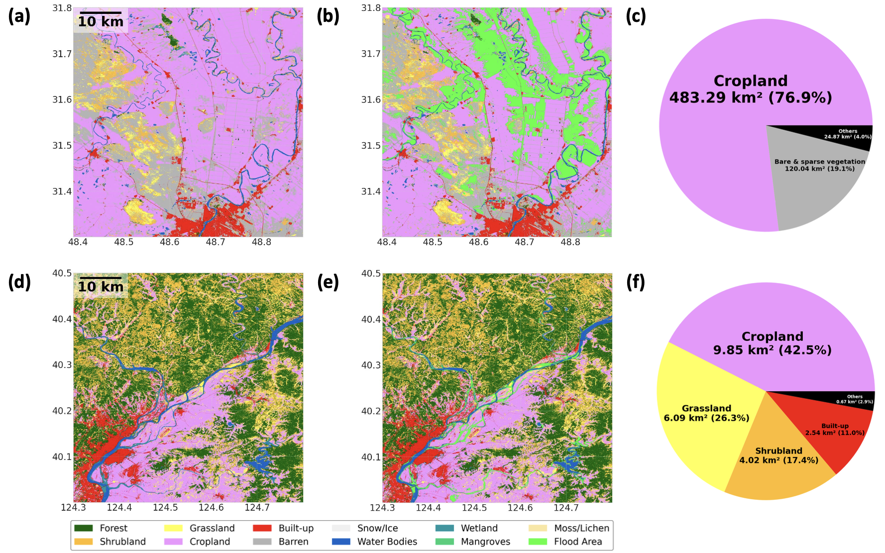
After flood mapping, the predicted inundation masks are combined with land use and land cover datasets to assess the distribution of flood impacts across croplands, grasslands, shrublands, and urban areas. This step transforms the project from simple flood detection into full flood impact investigation.
What We Found
The results reveal a very important lesson. Models that relied only on standard dual-polarization backscatter features performed very well in the region where they were trained, but their performance collapsed when transferred to the unseen target domain. In some cases, F1-score and IoU dropped dramatically, showing that high source-domain accuracy alone does not guarantee real-world usefulness.
In contrast, the proposed PolSAR-informed and texture-optimized approach remained highly stable across domains. The best-performing model, Gated Shape CNN with the optimized feature subset, achieved outstanding target-domain performance with minimal degradation, maintaining strong structural integrity and flood boundary delineation even in the unseen North Korea case.
This means that the project was not just improving local accuracy. It was identifying the kinds of features and AI architectures that are fundamentally more robust for flood mapping under severe domain shift. That is exactly what is needed for monitoring floods in inaccessible regions.
Investigating Flood Impacts Beyond Flood Extent
One of the most important contributions of this project is that it moves beyond flood extent mapping and investigates flood impacts in terms of what land cover types were affected.
In the Iran source domain, the flood impact assessment showed that the event was overwhelmingly agricultural. Most of the inundated area was cropland, while built-up urban impact was very limited. This suggests that the main consequences of that event were likely related to agricultural losses, crop damage, and longer-term food security concerns.
In the North Korea target domain, however, the damage pattern was much more diverse and alarming. While cropland still represented a major portion of the flooded area, a substantial share of the inundation also affected grasslands, shrublands, and most critically, built-up urban areas. This indicates a much more immediate humanitarian and infrastructure risk, including threats to settlements, sanitation, and public safety.
This contrast highlights why flood impact investigation is so important. Two flood events may appear similar in terms of overall water extent, but their consequences can be completely different depending on where the water spreads. By combining AI-based flood mapping with land cover analysis, the project provides more actionable information for emergency response and recovery planning.
Why This Matters
This project is important because it addresses one of the most urgent and underexplored challenges in disaster monitoring: how to produce reliable flood information in regions where direct observations do not exist.
Its significance lies in three major areas.
First, it shows that domain-robust flood mapping is possible. A model trained in one environment can be transferred to a completely different one if the feature representation is carefully optimized for invariance rather than local fit.
Second, it demonstrates that satellite-based AI can support not only flood detection but also flood impact investigation. This adds practical value by helping decision-makers understand which sectors and land cover types are most affected.
Third, it offers a scalable path toward global flood monitoring in inaccessible regions. Since many disaster-prone areas lack dense ground networks, methods that do not depend on local retraining or in situ calibration are essential for real-world deployment.
Tools and Expertise
This project builds on advanced expertise in remote sensing, AI, and flood analysis:
Programming: Python-based workflows for SAR processing, optimization, and deep learning
Satellite Analysis: Sentinel-1 dual-polarization SAR, PolSAR decomposition, and textural feature extraction
AI Modeling: CNN-based semantic segmentation models for robust flood mapping
Optimization: Metaheuristic feature selection to identify transferable input structures
Spatial Analysis: Land use and land cover overlay for flood impact investigation
Domain Knowledge: Flood processes, SAR scattering mechanisms, and disaster monitoring in data-denied regions
Key Areas of Research Interest
In addition to this project, our broader research explores the following directions:
(1) AI-based flood mapping under severe domain shift
(2) Satellite monitoring of floods in inaccessible and politically isolated regions
(3) PolSAR-informed deep learning for water disaster analysis
(4) Transferable remote sensing models that do not require local retraining
(5) LULC-based flood impact assessment for humanitarian and infrastructure applications
(6) Integration of SAR, optical, and multi-source satellite datasets for disaster monitoring
(7) Scalable Earth observation frameworks for global hazard resilience
Broader Impact
By advancing domain-robust flood mapping with AI and satellite data, this project contributes to a more resilient and inclusive disaster monitoring framework. It helps close the information gap in regions where conventional flood assessment is not possible, and it enables more informed decision-making when rapid situational awareness is most needed.
Ultimately, this work supports a future in which satellite remote sensing and AI can provide near-real-time, reliable flood impact information not only in well-monitored countries, but also in the world most inaccessible and vulnerable regions.