Accurate soil moisture information is essential for improving weather prediction because soil moisture directly regulates land-atmosphere exchanges of water and energy. It influences evapotranspiration, surface heating, boundary-layer development, and ultimately precipitation formation. Since soil moisture has strong memory compared to atmospheric variables, better initialization of land surface conditions can improve short- to medium-range weather forecasts, especially near the surface.
However, soil moisture is difficult to observe globally with sufficient spatial and temporal coverage using ground networks alone. Many regions lack dense in situ observations, and even where networks exist, they are often too sparse to represent large-scale variability. Satellite remote sensing offers a practical solution by providing repeated global observations of near-surface soil moisture from microwave sensors. Yet no single sensor is perfect. Different sensors observe different soil depths, have different spatial footprints, and respond differently to vegetation, roughness, temperature, and topography.
This is why multi-sensor soil moisture data assimilation is so important. Active radar-based and passive radiometer-based soil moisture products each provide valuable but incomplete information. When they are assimilated together within a land-atmosphere coupled prediction system, their complementary strengths can be better utilized to constrain land surface conditions and improve weather forecasts.
Our Goal
We aim to investigate whether simultaneously assimilating radar-based and radiometer-based soil moisture retrievals can provide synergistic benefits for numerical weather prediction. (check out our publication; link)
Specifically, our study evaluates the combined impact of assimilating ASCAT and SMAP soil moisture retrievals into the Korean Integrated Model using a weakly coupled land-atmosphere data assimilation framework based on the NASA Land Information System. ASCAT provides C-band radar-based soil moisture information with finer spatial detail, while SMAP provides L-band radiometer-based soil moisture retrievals with strong sensitivity to soil moisture variability.
Our goal is not simply to test whether each sensor individually improves soil moisture estimates, but to determine whether using both together can produce more balanced and robust improvements in atmospheric analysis and forecast performance, including near-surface humidity, temperature, and precipitation.
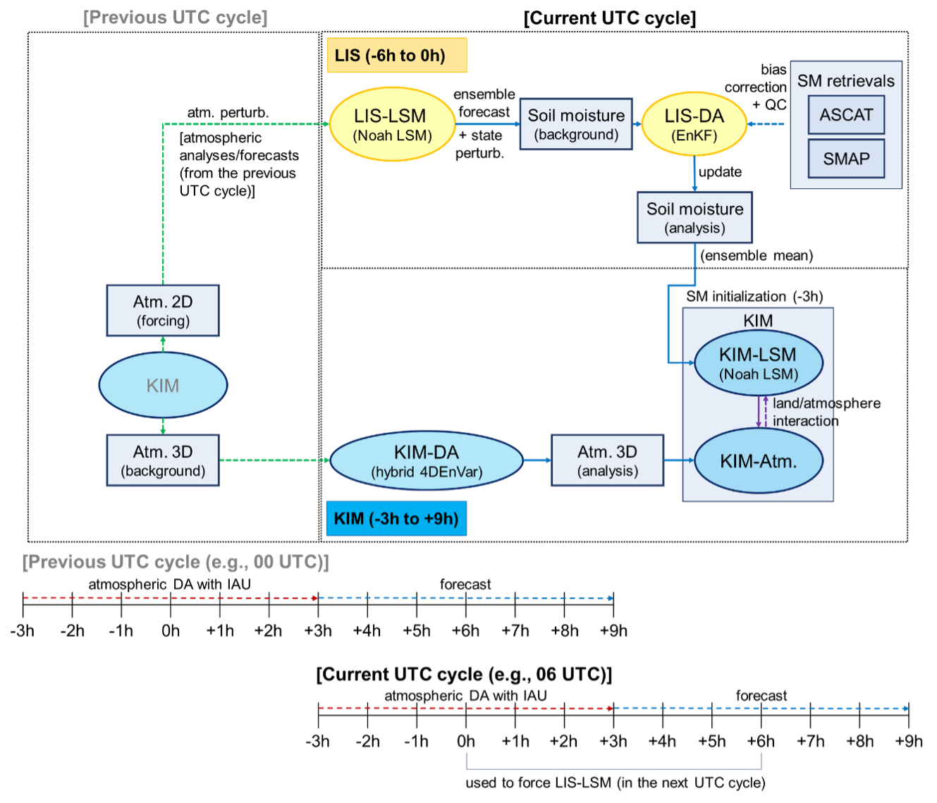
Our Approach
Our framework is built on the KIM-LIS coupled system, where atmospheric and land data assimilation are implemented separately but exchange information every analysis cycle.
Within this system, the Noah land surface model in LIS simulates soil moisture states and assimilates satellite soil moisture retrievals using an Ensemble Kalman Filter. The resulting land analysis is then passed to the Korean Integrated Model to initialize land surface conditions for atmospheric forecasts. In this way, improved soil moisture information influences lower atmospheric conditions and subsequent weather prediction.
We conduct four experiments. The first is a control case without soil moisture assimilation. The second assimilates only ASCAT soil moisture. The third assimilates only SMAP soil moisture. The fourth simultaneously assimilates both ASCAT and SMAP soil moisture retrievals. This design allows us to compare the relative contributions of single-sensor and multi-sensor assimilation.
Because radar- and radiometer-based products have different units, climatologies, and error structures, appropriate preprocessing is essential. ASCAT soil moisture is bias-corrected using cumulative distribution function matching, while SMAP soil moisture is bias-corrected using an anomaly correction approach that preserves temporal variability. After quality control and bias correction, the observations are assimilated into the Noah land surface model, and their impacts are evaluated on soil moisture analysis and atmospheric forecast performance.
Why Using Both ASCAT and SMAP Matters
ASCAT and SMAP have complementary strengths. ASCAT, based on active microwave backscatter, provides relatively finer spatial detail and can capture useful soil moisture patterns over many regions. However, it is more vulnerable to topographic effects and can be affected by subsurface scattering under dry conditions. SMAP, based on passive microwave brightness temperatures, is generally more sensitive to soil moisture variability and often provides higher retrieval accuracy, but it can be more strongly affected by vegetation and surface temperature.
Because of these differences, each product can outperform the other depending on region, season, land cover, and meteorological conditions. Assimilating them together offers the possibility of reducing overreliance on any single product and achieving a more balanced representation of land surface moisture conditions.
This is particularly important for coupled weather prediction systems, where soil moisture errors can propagate into air temperature, specific humidity, and precipitation forecasts. A multi-sensor approach can therefore help not only the land analysis itself, but also the atmospheric response to improved land initialization.
Main Findings
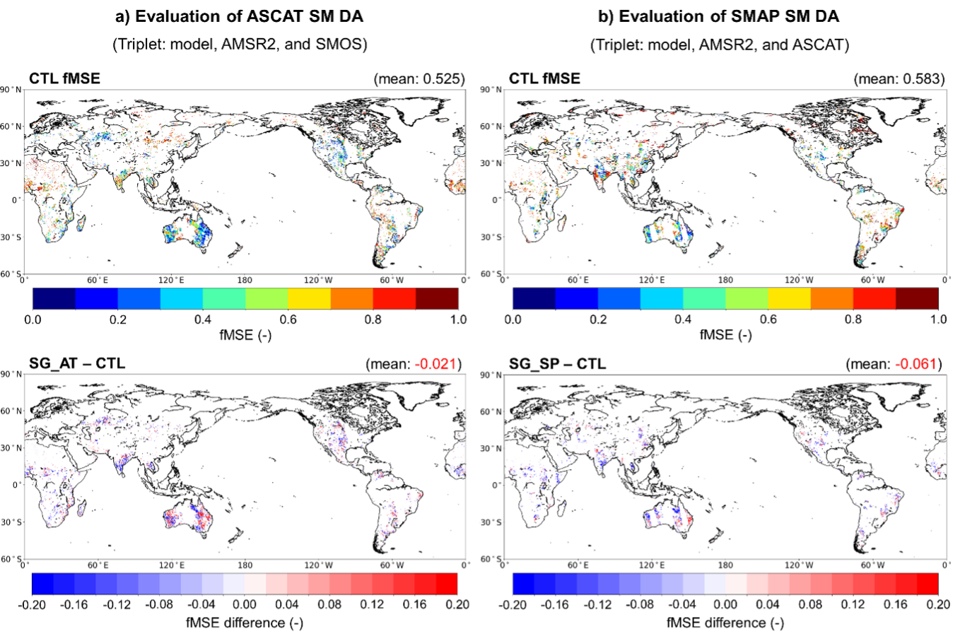
Our results show that assimilating either ASCAT or SMAP improves global soil moisture analysis relative to the control case without soil moisture assimilation. ASCAT assimilation improves global soil moisture analysis accuracy by about 4.0 percent, while SMAP assimilation improves it by about 10.5 percent. The strongest gains are found in croplands, where satellite observations appear especially effective in constraining the modeled soil moisture.
For atmospheric variables, the two sensors show different strengths. SMAP assimilation generally provides stronger improvements in specific humidity, while ASCAT assimilation tends to contribute more to air temperature improvements in some cases. Most importantly, simultaneous assimilation of both ASCAT and SMAP produces more balanced performance across both variables than either single-sensor experiment alone.
The clearest synergistic benefit appears in 2-m air temperature analysis and forecast. When both soil moisture products individually have positive impacts, assimilating them together produces the strongest improvements. In other words, the multi-sensor system is particularly effective when the two observation sources provide complementary and mutually supportive information.
We also find that precipitation forecast skill can benefit from multi-sensor soil moisture assimilation. In particular, event-based precipitation prediction, evaluated using the equitable threat score, improves when both soil moisture products are used to constrain the land surface. This result is important because it demonstrates that better soil moisture initialization can propagate through land-atmosphere coupling and improve precipitation forecasts, not just near-surface land states.
Broader Importance
This work is significant because it demonstrates the practical value of multi-sensor land data assimilation in an operational numerical weather prediction framework.
Many previous studies have evaluated soil moisture assimilation in offline land systems or using only one satellite product. In contrast, this study investigates the simultaneous assimilation of ASCAT and SMAP within a global land-atmosphere coupled system linked to an operational weather model. This makes the work highly relevant for real-world forecasting applications.
The study also shows that assimilating individual radar- and radiometer-based soil moisture products separately, rather than using a pre-blended product, offers important advantages. It provides more flexibility, makes it possible to account for the relative reliability of each sensor, and is more suitable for near-real-time operational forecasting where data latency matters.
In this sense, the work is not only about improving soil moisture analysis, but about advancing the next generation of coupled land-atmosphere prediction systems that can integrate diverse satellite observations more intelligently and effectively.
Remaining Challenges
Although the results are promising, several important challenges remain.
One issue is the quality of ASCAT soil moisture retrievals under dry conditions, where subsurface scattering can degrade the relationship between backscatter and soil moisture. Another challenge is bias correction. Current approaches such as cumulative distribution function matching can introduce information loss, especially for products like ASCAT that differ substantially from model soil moisture climatology.
A further challenge is the specification of observation errors. In this study, observation error values are largely uniform in space and time, which does not fully reflect the real uncertainty structure of soil moisture retrievals. Because the relative performance of ASCAT and SMAP varies regionally and seasonally, future systems would benefit from spatially or spatiotemporally varying observation error estimates. This would help the assimilation system weigh each product more realistically and improve the performance of multi-sensor assimilation.
Tools and Expertise
Our research builds on advanced capabilities in land-atmosphere modeling, data assimilation, and satellite remote sensing:
Programming and Modeling: Numerical weather prediction and land surface modeling using KIM, LIS, and Noah
Data Assimilation: Ensemble Kalman Filter for land assimilation and hybrid 4DEnVar for atmospheric assimilation
Satellite Remote Sensing: Active microwave soil moisture retrievals from ASCAT and passive microwave soil moisture retrievals from SMAP
Bias Correction and Quality Control: Sensor-specific preprocessing for consistent assimilation into land surface models
Forecast Evaluation: Triple collocation analysis, RMSD-based atmospheric verification, and categorical precipitation skill metrics
Domain Expertise: Soil moisture, land-atmosphere coupling, numerical weather prediction, and operational forecasting systems
Key Areas of Research Interest
In addition to this study, our broader research explores the following directions:
(1) Multi-sensor soil moisture data assimilation in operational weather prediction systems
(2) Land-atmosphere coupling and its role in temperature, humidity, and precipitation forecasts
(3) Sensor-specific bias correction strategies for microwave soil moisture retrievals
(4) Spatially distributed and time-varying observation error modeling for land data assimilation
(5) Improving precipitation forecast skill through better land surface initialization
(6) Integrating radar, radiometer, GNSS-R, and future satellite observations into coupled forecasting systems
(7) Building scalable and flexible land data assimilation frameworks for real-time forecasting applications
Broader Impact
By showing that radar- and radiometer-based soil moisture retrievals can be assimilated together to improve weather prediction, this research supports a more comprehensive and operationally meaningful use of satellite land observations.
The results suggest that future forecasting systems can benefit from combining complementary satellite products rather than relying on a single source of soil moisture information. This is particularly valuable for global and regional weather prediction, where land surface initialization plays an important role in forecast skill.
Ultimately, this work contributes to improved atmospheric analyses, better forecasts of near-surface temperature and humidity, and more reliable precipitation prediction. It also provides a practical pathway toward more advanced multi-sensor land-atmosphere data assimilation systems for next-generation operational forecasting.